History
Exhibit illustrates the year 1940 as turning point for the state of Nevada from ranching and mining to tourism, recreation, and gaming
LAS VEGAS (September 12, 2025) – The Nevada State Museum, Las Vegas, located on the campus of the Las Vegas Springs Preserve at 309 S. Valley View Blvd., has announced their newest exhibit, […]
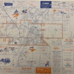
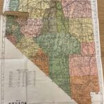
 1964 Camping Map of Nevada
This 1964 Nevada Camping Map is from our collections, and was published by the Nevada Department of Economic
Development. It details a variety of Forest Service, National Park and BLM campgrounds and outdoor recreation areas located throughout the […]
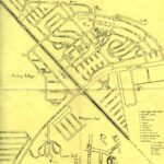 1940s Map of Henderson, NV
1940s Map of Henderson, NV
This map, from our collections was created by Woodruff’s Basic Photo of Henderson, NV, and shows the Basic townsite built to house workers of Basic Magnesium, Inc. (BMI). BMI opened in 1942 to process magnesium needed for WWII. It created a migration of out-of-town workers and their families to the […]
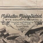 1917 Map of Manhattan Mining District
While today Manhattan, NV is considered a ghost town, it once was a thriving mining area as this Manhattan Mining District map from 1917 shows. Located on the slope of Bald Mountain, its origins began with a silver strike in the 1860s, although this was depleted by 1890s. In 1900 gold was found, the town […]
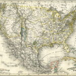 1850 Map of United States of America
View Map
From our collections, we have a German map titled, “Vereinigte Staaten von Nord America und Mexico, 1850” or United States of America and Mexico, 1850. The map shows a large area marked simply as “desert” that would eventually become the states of California, Nevada, and Arizona.
While by 1850 Las Vegas was typically being […]
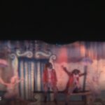 International Clown Week
In celebration of International Clown Week, the first week in August, from our collections, we have a 1966 film clip of the George Moro dancers at the Sahara Hotel and Casino in 1966. This features slapstick circus clowns performing to the music from the prior year’s hit ‘Everyone Loves a Clown’ by Gary Lewis […]
 1950s Map of Las Vegas
1950s Map of Las Vegas
From our map collection, we have this map of Las Vegas, from the late 1950s, captures the Strip at a unique time. The map shows the Royal Nevada, the Dunes and the Riviera, all of which opened in 1955 to varying degrees of success. The Royal Nevada would eventually close […]
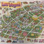 1991 Cartoon Map of Las Vegas
1991 Cartoon Map of Las Vegas
From our map collection, this cartoon styled map of Las Vegas was produced in 1991.
1991 Cartoon Map of Las VegasSome of the landmarks depicted are still around today, such as the Excalibur, Tropicana and Ethel M., and the Nevada State Museum, Las Vegas when it […]
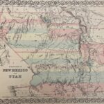 1855 Colton’s Territories of New Mexico and Utah Map
1855 Colton’s Territories of New Mexico and Utah
1855 Colton’s Territories of New Mexico and Utah MapThis map is an 1855 first edition of Colton’s Territories of New Mexico and Utah depicting the area from which the territory of Nevada would eventually be created.
Look closely and you can see “Vegas” marked […]
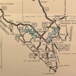
 1919 Kenyon’s Pocket Map of Nevada
1919 Kenyon’s Pocket Map of Nevada
Cover of the 1919 Kenyon’s Pocket Map of Nevada
Welcome to #MapMonday where we highlight one of the fascinating maps from our collection.
Although a little tattered, this 1919 Kenyon’s Pocket Map of Nevada illustrates the way the state has changed. If you look at Clark County, […]